Once more 'round the park

4 comments
It's 11:30 pm.  I have to be up in a little over 6 hours to catch my plane to Maui.

It'll be Tau day in a few minutes - tau being twice pi, or ~6.28.  6/28/2012 is also the 43rd anniversary of the Stonewall riots.  It's the 93rd anniversary of the signing of the Treaty of Versailles ending World War I - and, ironically, the 98th anniversary of the assassination that started it.

And, 35 years ago, the 28th of June was a Tuesday.  My mom hadn't gone into labor over the weekend and was now 24 days late, so her doctor made the decision to induce labor.  Tuesday was chosen because Mondays at the hospital were typically busy.  A couple hours after being induced, she had a 9 lb 8 oz baby boy, whose first act upon being placed on the gurney was to pick his head up and look around the room.

"Should he be able to do that?" my mom asked.

"You cooked him an extra month," the doctor replied, "What did you expect?"

... The silly part is that the only thing being "35" brings to mind is that I'm only 2 years away from being a prime number again.

Oh well.  See y'all when I'm in Maui.

Two words, sounds like...

3 comments
Work's been hell this week.

During a normal week, Thursdays tend to be "meeting day" with a few on Tuesdays.  This week, I was in meetings most of the week; the only day I really had much contiguous time to work on anything was Monday.

Add to that the fact that my manager told me Monday morning that she wanted a user manual for the software we've developed by Friday.  We had a crappy, half-a-dozen page one for the last version, but since we've changed pretty much everything, it needed to be rewritten from scratch.

So, this whole week has been me going back and forth to meetings and dragging my laptop with me so that I can half-ignore the meeting I'm in and work on the manual.  I've also worked at home, after hours, more this week than I have since I started the company (I'll be doing more tonight, and likely this weekend - no, I'm not done, but I got a significant amount of what she wanted done so she could review it, so she's happy).

Next week, I need to get officially stabbed (for my annual TB test) and, again, meetings half of Monday and all of Tuesday.  Wednesday looks to be mostly open at this point, but we'll see how it works out.  However, by Wednesday afternoon, I'm not going to care.

Because, Thursday, June 28th, I'm flying back to Maui for 9 nights in a penthouse on the beach.

Fuck.  Yeah.

Homeward Bound - Day Three

1 comments
(All these shots and more, except the map, available at flickr.  Map courtesy of Google.)

This last post is shorter, but so was the journey.  After spending the night in Garberville, we needed to get to a train station in Martinez by 3 pm or so.  The fastest way was 200 miles down the 101, which was a regular freeway or at least a major highway for most of the trip.  However, since we had some time and my wandering companion expressed a desire, we cut off the 101 just north of the bay and headed east.

The last of the western frontier.
As I said in the last post, the 101 north of the bay is known as the "Redwood Highway".  It winds through a small valley  in the center of the coastal mountains, past tree-filled hills and small rivers.  In fact, the first hundred and twenty miles or so south of Garberville - itself a barely-there town - have almost no habitation, just small ranches or truck stops here and there.  The first "city" one gets to is Santa Rosa, which is actually the largest town in Sonoma County and one of the largest in the so-called "wine region".

For, indeed, this is where California wines come from.  The trees covering the hillsides gradually give way to vineyards as one crosses into Sonoma County.  98% of the grapes eaten in the US come from California, and most of them come from this region.  We cut east before reaching Santa Rosa and took Highway 128 past areas that should sound familiar to any wine aficionado: Alexander Valley, Calistoga, and eventually to Napa Valley itself.


It was the 49ers who brought grapes to California - a few enterprising individuals decided that it was easier to grown their gold than pan for it.  The first wines were produced for sale in the late 1850s, and it's been going ever since.  This part of California is roughly the same latitude as most of France and of similar climate.  Most kinds of wines are produced here, even sparkling wines that are champagne in everything but name (a thorny legal issue).

In fact, in an interesting bit of history: France uses Californian vines - to a point, anyway.  In the 1800s, speedy transportation across the Atlantic meant more travel, and when California started growing its own varieties of grapes, some of those vines made it back to France.  Unfortunately, along with those vines likely came an aphid that carried a blight.  While it didn't affect the California vines much, it wiped out almost all French vines - until a solution was found, whereby French vines could be grafted onto Californian ones and survive.  To this day, I think there's only one native European vine that, ungrafted, can survive the blight, and it only grows in Greece.

Regardless, the California wine industry is extremely successful, and Napa is its cultural (if not literal) center.

It's also only a short hop from there to Martinez, and the end of this part of the journey.  We arrived at about 2 pm, plenty of time for Mark to catch his train and wander on as well as for me to start the drive home - a pretty bland 400-mile drive down the 5 back to L.A., one that normally takes about 5 or 6 hours but ended up taking over 7 because of construction (ironically at a place called the Grapevine, though that's because of how it winds up the Tehachapis rather than anything to do with actual grapes).

All in all, I think it was a fun trip.  I've been on many parts of these roads before, though in some cases it has literally been almost three decades.

My ulterior motive, though, and even my reason for writing up these "travelogues" as they've been called, is to get across some of the diversity of California.  I love this state - I've lived here all my life - and while I acknowledge the importance of Hollywood and the Silicon Valley to the culture and commerce of both the state and the nation as a whole, there's so much more here that most people - even most Californians - never experience.

In the 80's, there was an old show called "California's Gold" starring Huell Howser, where he wandered around the state finding small, interesting, out-of-the-way spots or sights that most people would never know about.  Part of me would like to reproduce - in a more modern way - some of that on this blog.

I still want to get out to the deserts.  I want to camp in Yosemite and spend a week at Tahoe.  I want to go back to Big Bear and Shasta and really get into the sequoias.  I want to head over to Catalina and the rest of the Channel Islands, to wander down to San Juan Capistrano and walk around the San Diego zoo and wild animal park.

And, yes, I want to go to Europe, and South America, and Africa, and Australia, and scores of other places, but those all take far more planning and longer time than a weekend.  That doesn't mean they won't happen, but it means they'll happen less often.  I hope to do a trip around my state once every month or two - perhaps not to this extent (1400 miles in 3 days is a lot), but maybe.

Anyway, I hope this gives any of you who plan on visiting - or who have been living here for years but never really looked around - some ideas of what's out there.

Pacific Coast Highway - Day Two

1 comments
(All these shots and more, except the map, available at flickr.  Map courtesy of Google.)


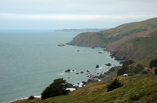
I mentioned in my last post that most of that day's drive took place on the Pacific plate.  If you look at this fault map, you can see what I mean:

From the upper left, there's a dark line - the San Andreas Fault - that cuts off just south of San Franciso itself then cuts inland slightly but still roughly follows the contour of the state.  That fault separates the Pacific plate - everything left of it - from the North American plate - everything to the right.  Also, if you notice the green area just to the right of the San Andreas in Northern California, that's mesozoic-era rocks that are part of the plate.

What this means is that the actual soil and ground are extremely different along the coast north of the bay area than they are south of it.  For example, because of the addition of volcanic elements from the Cascades, you often find black sand beaches in northern California that don't exist in Southern California.

And yes, this is where we make the joke that, while California has many faults, lack of diversity isn't one of them.  Anyway, for the record, the plate action is such that Los Angeles (and the parts of California on the Pacific plate) is actually moving northward slightly towards San Francisco.  This is also increasing the size of the Sea of Cortez as the action creates a "gap" that will, in millions of years, probably reach up to Lake Tahoe.

Back to the trip...

Sunday started later than Saturday - we weren't rushing to get to the aquarium this time, but it was going to be a long slow slog.  Saturday's drive time was around 9 hours for 400 miles; Sunday was about the same distance but with nearly zero freeway(1) miles, so much slower (ended up taking us almost 13 hours).  Anyway, we slept in until 7ish and were on the road by 8.

First stop is the quiet little town of Santa Cruz, at the north end of Monterey Bay.  Santa Cruz is best known for surfing, a college, and its boardwalk - which is pictured here.  The boardwalk has the fifth oldest coaster in the US - it opened pre-Depression - but was obviously closed so early in the morning.

The college I mentioned is University of California (UC) Santa Cruz (SC), one of California's public universities.  It's nestled in the hills and trees just north of town.  UCSC's major focus is on marine biology - logical, since Monterey Bay is part of a large protected area for marine reserves that stretches from San Francisco south almost to Morro Bay.  The fun fact about UCSC is its mascot: the banana slug.

Leaving Santa Cruz, we headed along the coast up to Half Moon Bay, a fairly famous golf course and resort getaway for bay area types.  However, just north of the bay is more famous for surfing: surfers generally acknowledge three amazing spots in the world for the best waves year-round, one in Maui (Jaws) and two in California - and Mavericks is by Half Moon Bay.  Waves average - and yes, I said average - 50 feet, with crests over 80 feet. 

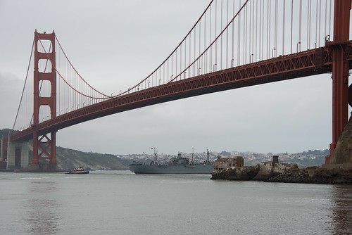
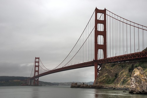
We didn't go surfing.  Instead, we headed up PCH and joined up with the 101 as we got to San Francisco.  Mark had little actual interest in the city itself - he's coming back at a later juncture - so we just drove through town, but I did want to make sure we stopped and got pictures of the Golden Gate Bridge if the weather cooperated.

Well, the weather was great, but something else made it a bit more difficult than it should have been: apparently, May 27th, 2012, was the 75th anniversary of the bridge, and so most of the viewing areas were closed off for press events.  Eventually we wound down a road to a little marina.  I've put in some of the shots, as well as one of SF from across the bay and Alcatraz through the haze.
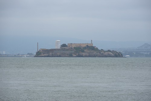
Alcatraz


San Francisco looking south


That bottom left shot is there to give you an idea of the size of the bridge: navy ships regularly go under it.  That one passing under it is the SS Jeremiah O'Brien, stationed in SF and one of the few surviving ships (there are only two confirmed from what I can tell) from the Normandy armada of D-Day 1944.

In the San Francisco shot, you can make out the pointy TransAmerica building almost dead center as well as the Bay Bridge on the left.

Bolinas

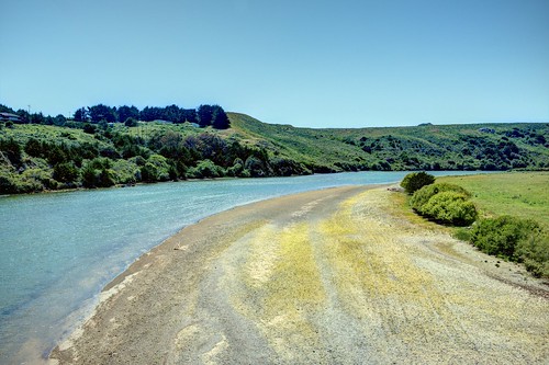
Leaving the bridge and getting back onto the highway was a little tricky, but we did.  North of SF, PCH follows the coast briefly to a "day trip" spot for beachgoers, Bolinas Bay.  The bay itself actually looked more like a salt-water marsh, but I think we were passing at low tide.  This shot is approaching, with the opening of the bay beyond that promontory.


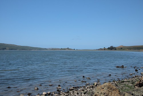
Tomales Bay looking north at the mouth
From there, PCH cuts inland a bit heading north-northwest to Point Reyes - everything west of PCH at this point is a National park.  Point Reyes itself is situated at the end of Tomales Bay.  It's at this point that the scale of the map is a bit deceiving, as Mark noted: Tomales Bay is barely a notch in the coastline of California, but the bay itself is 11-12 miles long.

At the end of Tomales Bay, after PCH curves inland a bit and then heads almost due west, you come to Bodega Bay.
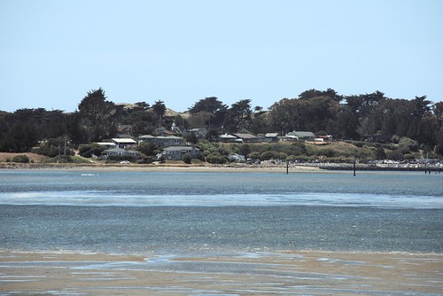
Bodega Bay

The town of Bodega Bay is a little fishing village with a very small population that, while picturesque, probably wouldn't be noticed by most people if it weren't for Hollywood.  This is where Hitchcock - who seemed to love the small little coastal town that reminded him of England - filmed his movie "The Birds", often touted as the first "fantasy/horror" movie. 


... no idea why he was up there...
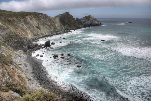
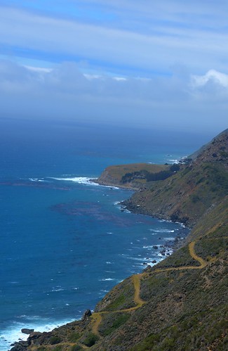
Bodega also, of course, has a small beach just north of town, and a lot of rugged coastline north of that.  I'd probably make the statement that, eventually, you get ill from all the picturesque little coves with quaint fishing villages in them as you drive up PCH. 

The coastline is rather beautiful, though, and weaving in and out of shores lines with trees (often redwoods) is fairly relaxing.
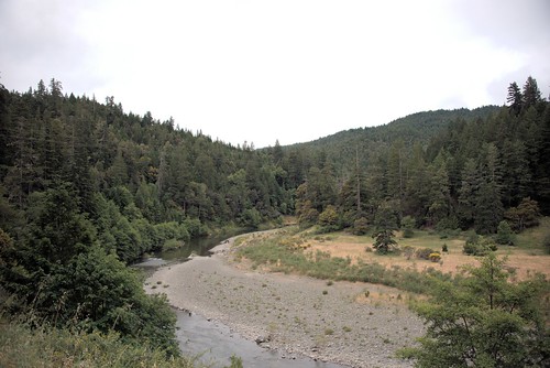
The Russian River
Also, there are occasional moments that stand out more, like crossing the Russian River.  I'm very familiar with this spot, as the resort town I frequent - Guerneville - is along the Russian River about 20 miles inland from this spot.  To the south-east is a small town called Sebastapol, along the Bohemian Highway, where a friend and ex-classmate of mine has a nifty little brewpub.


There are plenty of shots along the coastline; I'll just put some of the more interesting ones here.


About 30 miles past Fort Bragg, PCH leaves the coast for the last time(2) and joins back up with the 101, now the Redwood highway, in - you guessed it - the middle of the redwoods.  Robert Frost's statement definitely sprang to mind as we drove the winding road in the late afternoon:
The woods are lovely, dark and deep,
But I have promises to keep,
And miles to go before I sleep,
And miles to go before I sleep.

We reached the 101 just before 7 pm - still daylight at this time of year - and had to take a touristy detour.  You see, we had to drive through a tree.
Think thin

The Chandelier Tree is a pretty famous attraction here.  There's a similar one, if I recall correctly, up by Yosemite, but this one's near enough to the Avenue of the Giants that it gets a fair bit of traffic.  Yes, you drive your car through the base of the tree.  Yes, the tree is still alive.  It was a tight fit for my Eclipse - I certainly wouldn't try it with a full sized van - but we made it.

We then hit the 101 and drove north to the Avenue of the Giants.  Now, to be clear, parts of the 101 here are less "freeway" and more "twisty windy road", but since we'd spend almost 800 miles on twisty windy highway, this wasn't much of an issue.  The fading light was, however, and I wanted to make sure we had time to see at least a few of the giants.  Even impossible-to-find markers along the self-guided tour didn't dissuade us: eventually, we found them.
These are smallish sequoias.

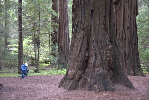
When people talk about "big trees", there are three distinct varieties in California.  The Douglas Firs are more common, a pine tree that's still been known to reach over 350 feet tall.  However, the biggest are the other two: the coastal redwood, which have been confirmed to grow up to 380 feet (and stories tell of much taller) but are relatively skinny (only 26 feet across).  The other is the giant sequoia, which only grow to 200-250 feet or so tall but can have diameters in excess of 50 feet.
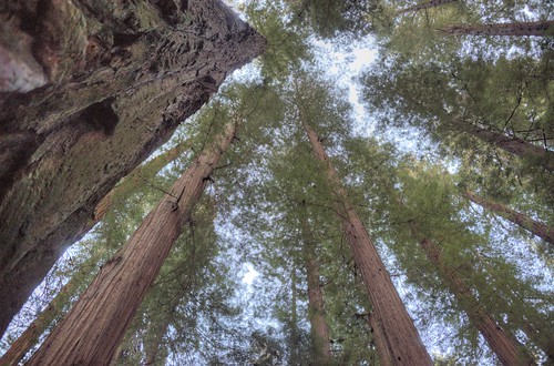
The canopy above

Redwoods - all types, including sequoias - have natural pest repellants in their bark.  Also, because the canopies are so high and light so dim at the base, not much grows between them other than other redwoods and low ferns or mosses.  The effect is that of a natural cathedral, with almost dead silence and a distinct earthy smell.

I always joke with people that California is known for excess: we have the largest animal that ever lived - the blue whale - living off our coast year-round, and we've got the largest organism that ever lived - the giant sequoias - living in our hills.  But, really, there is something otherworldly and ancient when you wander through a redwood forest - I often half-expect a Tyrannosaur to come stomping through.  The main response, though is best summed up by this last shot.
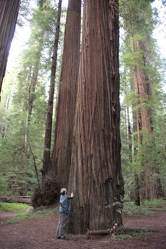
If you've never been, you don't know.
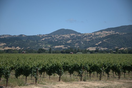
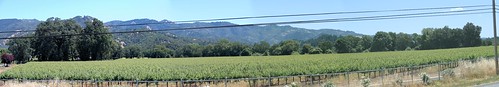
Sunset came up quickly, and we drove back down to Garberville for the night.  Next up, the last of the wine (or the wine road, anyway).

(1) Okay, so, nomenclature.  "Freeway" is just to distinguish from a "tollway".  There are very few toll roads in California.  Most of our major highways are freeways - in fact, I can only think of two tollways in SoCal, and both are optional routes that parallel freeways.
(2) Technically, the 101 goes back to the coast, but PCH as an independent road ends here.

Pacific Coast Highway - Day One

1 comments
(All these shots and more, except the map, available at flickr.  Map courtesy of Google.)

So, when the Wandering Pom told me he'd be coming out to California at the end of May, I asked if he had any interest in taking a drive around part of the state since he'd be here for Memorial Day weekend.  He consented, and we had some discussions about what should or shouldn't be on the list.  What resulted was a 3-day trip, starting very early Saturday morning, that mostly followed the California coast and some of the more scenic routes.

So, some basic facts: California is about 800 miles and, at its widest, about 250 miles wide.  However, the shape of the state means one drives diagonally for most of the length - going up the 5 freeway, which runs the whole length of the state, is about 800 miles from the Mexican border to Oregon.  For you Europeans, the state is almost the exact same size as the UK.

However, the 5 takes the shortest route: straight up the central valley.  While that has its own scenery, a lot of that is through the Central Valley - which means literally hundreds of miles of farms and cattle ranches.  While important to the agribusiness of the nation (CA is responsible for something like 10% of the foodstuffs of the US), it's pretty boring.

Much more scenic are the coastal routes - namely, the 101 (which weaves a bit along the coastal mountains) and, more specifically, Highway 1 or the Pacific Coast Highway.  In places, Highway 1 and the 101 overlap, but for most of its length, PCH follows the contours of the state.  It's this drive that we took for most of its length.

What you see mapped out above is the first day's trip from Pasadena (my humble abode) to Monterey Bay.  In "real distance", it's probably less than 300 miles between the two; the route mapped out ended up being almost 400.

Santa Barbara Mission
We started out about 6:30 on Saturday morning.  The first part of the drive was just along the 101; at about Ventura, it "merges" with PCH (which comes up from Malibu; we'd been there for dinner the prior evening) and follow the coastline for a while.  Our first stop, around 8 am, was in Santa Barbara - since we were following the El Camino Real for this part, I thought we ought to stop by at least one mission.

Unfortunately, God apparently likes to sleep in on the weekends and the mission was closed until 9 am, so we didn't get to go inside.  They were, however, setting up for some kind of festival outside, including a lot of chalk drawings (none of which were finished).  Instead, we hit a Starbucks for some refreshment and got back on the road.

North of Santa Barbara, the 101 follows the coast a bit and then curves inland at Gaviota State Park(1).  About here is where PCH and the 101 split for a while, and so we took PCH - here called the Cabrillo Highway, which it was named for most of Saturday's trip - back west a bit.  I'd hoped to get to drive closer to Vandenberg Air Force base - they do a lot of test launches and such there - but we were stopped by a rather polite person at a gate and made to go back.  Oh well.

North of Vandenberg, PCH winds through the hills and some small towns, meeting up again with the 101 briefly at Pismo Beach (famous for its sand dunes); just past Pismo, we actually jumped off of PCH and cut across on Los Osos Valley Road (no bears were sighted) towards Morro Bay. 
Morro Bay as we approach

Morro Bay's a cute little town, known for quite resorts and foggy ocean views (as you can see).  This shot shows the large rock for which the town is named - mostly likely by Filipino immigrants in the late 1500s (yes, 1500s; Columbus wasn't the only sailor out there, you know).

How about a nice game of chess?


The town itself it a quiet little fishing and tourist village.  Most of the resorts are along the coastline just to the north, around the golf course.  The most famous is simply called The Inn at Morro Bay.

From Morro Bay, we again joined PCH and continued north, often cutting inland a fair bit before heading back to the coast.  This part of California is technically on the Pacific plate; while it's not being subsumed at this spot(and so rumors of L.A. disappearing under the sea aren't very accurate), the constant pressure and slip motion - as well as the motion of the continental plate shifting westward slightly - creates the mountains that not only form the Channel Islands but the hills and such along the coast.  California is, in a sense, defined by mountains - and their valleys: on the east, we've got the Sierra Madres that form the temperate barrier along with the Cascades (which are volcanic and of which Shasta, Rainier, Hood and of course Mt. St. Helens are the most famous; the Tehachapis that basically divide Northern and Southern California far more decisively than the cultural war between SF and LA; and tonnes of others.  The coastal mountains are simply referred to as the California Coastal Ranges.
San Simeon from below

In these coastal ranges, however, nestled a few miles north of Morro Bay above San Simeon Bay, is, well, San Simeon, the famous Hearst Castle.  Lambasted in Orson Wells' famous movie "Citizen Kane" as "Xanadu", the property is maintained by a trust(2) that actually owns most of the fields and hills surrounding it.  Unfortunately, getting closer involves a tour group and a lot of time we couldn't really spare, so this is as close as we got.

We got a bit closer to some other things, however.  Just past San Simeon is a fairly famous spot.  My mom says that, 20 years ago, it was just a dirt pull-out along PCH, but now it's a full-fledged parking lot.  And there's a reason why it's usually pretty busy:
They're not dead, they're resting.
This guy was making a lot of noise.

Elephant seals regularly relax out on the beaches below PCH. They're noisy and they're smelly, but it's one of the best viewing spots to watch them.  And they never seem to mind all of us gawking down on them.

Of course, they weren't the only wildlife there that didn't object to having people around...


These little guys (and gals) were everywhere.

Beyond that, PCH winds its way along miles - and miles and miles - of coastline up towards Monterey Bay.  There are basically no towns in between - I think we stopped for lunch as a little dive in Big Sur, which is a camp ground.  However, some of the views are impressive, so here's a few shots along the coast.


In Monterey, we hit the Monterey Bay Aquarium.  I didn't take my camera inside - there are some things that are better left experienced with both eyes.  I'll say no more on that, but if you ever have an opportunity to go there, you should take it - and plan a full day if possible.

After that, we just drove a few miles up the road to the hotel.  Dinner at a pub and lights out, because it was another long day of driving to come.

More in the next post, but I'll leave you with a photoshop I did of a photo I took with a caption from a friend on FB.

(1) I'll add a note here, because it came up in conversation.  In the US, there are two major groups that manage parks, the federal government (National Parks Service, NPS) and the state (Department of Parks and Recreation, DPR).  NPS only handles parks or locations which are deemed of national significance; coincidentally, NPS was founded in order to manage Yosemite National Park in eastern California around 1880.  The state handles most other areas, often in conjunction with private groups.


(2) An instance of DPR working with a private group to maintain a property.

World turning circles

3 comments
There's a little black spot on the sun today...

(Taken with my D800 with the Nikkor 28-300 lens and 3 filters - UV, ND8, and Polarizing - at L1.0 ISO, 1/8000, and f36.)

(For reference, I was facing west, so north is at the right of the picture.)